
Ideal places for your photo that speaks more than a thousand words

Today, however, technology allows you to not only see the photo immediately after "clicking", but you can also take photos until the frame is perfect. Social networks allow you to immediately "hang" the photo on your profiles. Instagram is the leading photo platform. It is therefore the leading platform for marketing and promotion - of people, business, natural and architectural beauty.
The most common user photos are related to natural beauty and interesting buildings. There is usually a certain pose in which a man is standing, and there is a beauty in front or behind him. This indirectly promotes the beauty of cities, regions and countries.
That Montenegro is known for its beauty is also visible on Instagram. There are many sites in our country that have been repeated on that social network for years. In this article we have identified some of them.
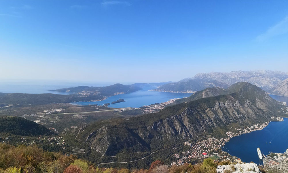
Njegoš Mausoleum on Lovćen

A staircase of 461 steps passes through the tunnel, leading to a stone terrace and a vestibule with a stone well. The mausoleum is an ensemble of architectural and artistic creations that make up: an atrium in the center of which is a well weighing four tons, porticoes on the left and right sides and two caryatids - Montenegrin women in national costume carved in black marble. The caryatids, one with her hand on her belt and the other with her hand on her heart, represent a mother and daughter.
All of us who "climbed" Lovćen, a symbol of Montenegro's national identity, did not return without a photo in front of the caryatid or on the hilltop while the view of Boka Kotorska stretches behind us.
Sveti Stefan

photo: Instagram.@boconiii
However, by far the most famous of them is the island of Sveti Stefan. It is the most luxurious resort in Montenegro and one of the most luxurious on the Adriatic Sea. According to the 2003 census, there were 411 inhabitants. The entire island is now one of Amman's hotels.
There is a lookout point on the highway, which is also the most popular place for taking photos on this island. Instagram is full of such photos of the popular "saint" - one of the most valuable pearls of the Montenegrin sea.
Ada Bojana and Long beach
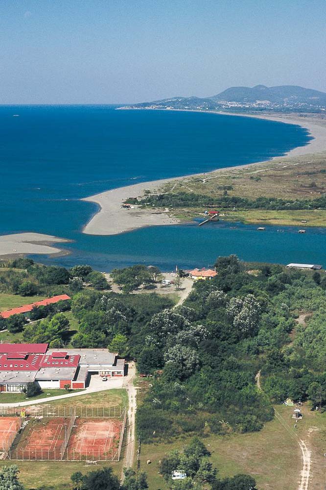
Ulcinj - the southernmost town in Montenegro, a former port of pirates, kilometers of shallow beaches and fine sand. The most beautiful sunrises and sunsets will await you at Ada Bojana and Ulcinj's Big Beach. Such scenes were recorded by many phones and posted on Instagram. There are few who would not think that the photos were taken on the beaches of California, instead of the southernmost Montenegrin beach.
Ada Bojana is a river island at the confluence of the Bojana River with the Adriatic Sea. According to legend, it was created in the 17th century, when the sailing ship "Merito" ran aground near two small islands due to a big storm. Over the years, the river sediment was deposited on the shipwreck and two nearby islands, and in this way the island was formed. During the Cold War, Ada was a military base with a heavily guarded border. This caused certain parts of Ada Bojana to be completely untouched nature.
Ada Bojana became popular as an ideal place for summer holidays only ten years ago, initially among people with somewhat alternative tastes and kite lovers. Kilometer-long shallows and wind make these endless beaches ideal for "riding the waves".
Ostrog monastery
The territory of Montenegro contains the religious wealth of the three most represented confessions in the region. The Cathedral of St. Tripun in Kotor, the Husein Pasha Mosque in Pljevlja and the Ostrog Monastery in Nikšić were declared cultural monuments.
Ostroška greda, which is the most frequently "sworn" by the Orthodox of the central region of Montenegro, is the most photographed, judging by Instagram. It is a monastery that is located along an almost vertical cliff, high on the Ostroška greda mountain in Montenegro. It is dedicated to Saint Vasilij Ostroška. From the road it looks like it's built into the rock. Ostrog Monastery consists of Upper and Lower monasteries.
Ostrog Monastery is one of the most visited religious buildings in Southeast Europe. Believers of all religions from all over the world come to it. Its popularity is very visible among Instagram users
Perast
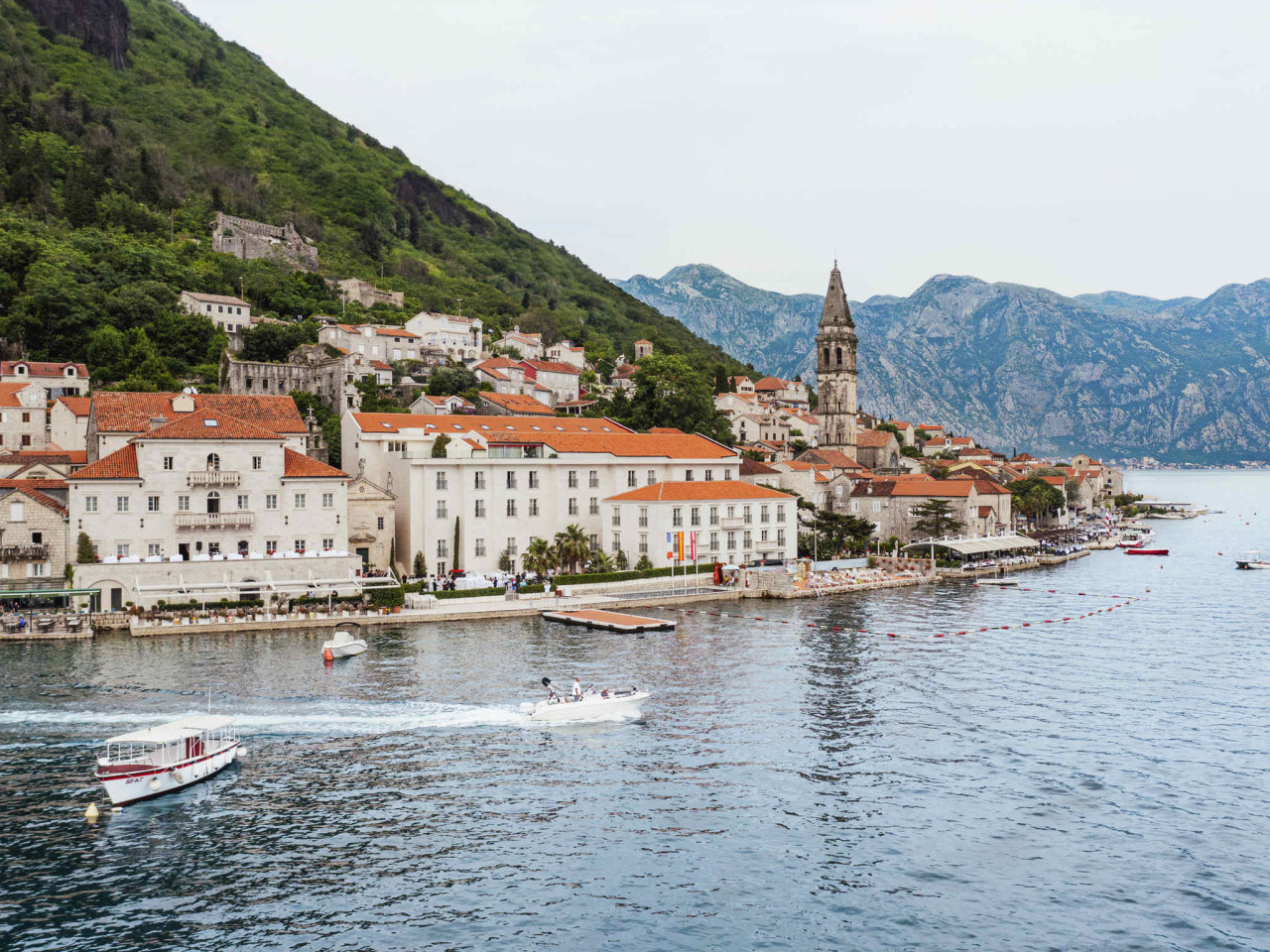
photo: Accor hotels
We have just decided on Perast, which would surely be at the top of the list of the most popular places in Boka in general. It is a settlement in the municipality of Kotor, at the foot of the Sveti Ilija hill and opposite the Verige strait.
perast defne kucukmustafa nud2Qpfo6lM unsplash
Alleys, narrow passages, stone buildings and the occasional friendly stray cat are what make Perast a real hedonistic destination, as well as a picture and opportunity for a postcard.
You won't go wrong wherever you point your camera in Perast, and a particularly popular subject of photography is the island of Gospa od Škrpjela, which is located in front of Perast. There is a church of the same name on the island itself, and you can get to the island from Perast by a short boat ride.
Old Bar (Fortress)
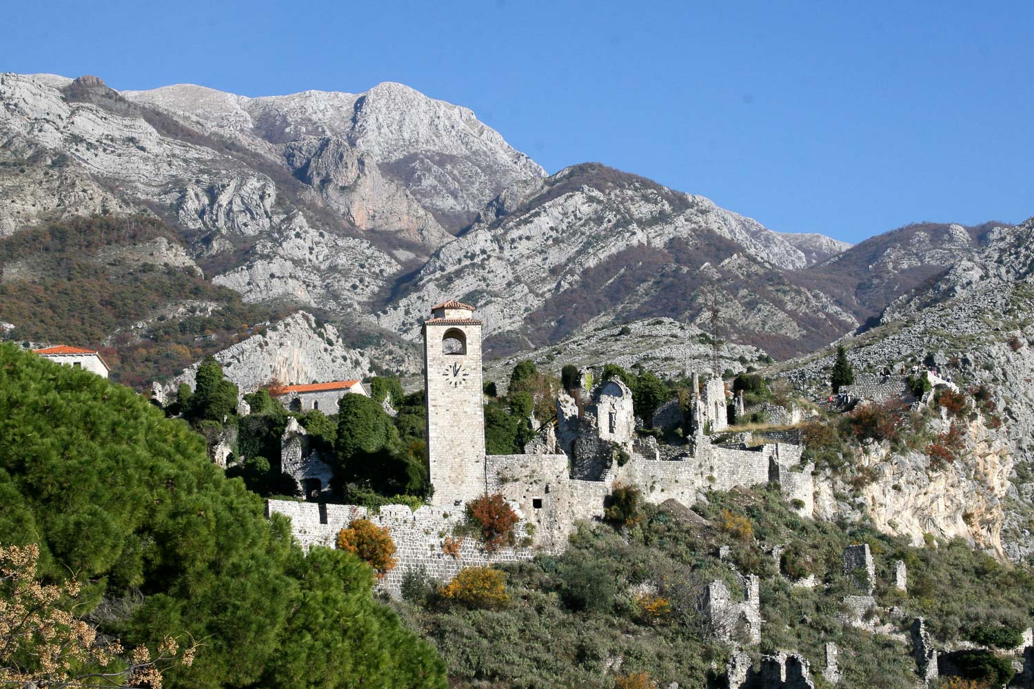
Every family in Montenegro has its own tribe and "house", the place from which they originated. Thus, every city has its roots, and the old stone walls would be its housing. Although the old town in Kotor has long been the most popular destination, Instagram has been "flooded" with photos of Stari Bar in recent years. Suddenly, a frenzy for this place broke out among the users of this social network.
It is a town settlement in the municipality of Bar. The old fortress was the center of Bar for many centuries, until the city moved lower, to the field. The old town of Bar is one of the largest archaeological sites in the world. Other monuments of this type are distinguished by their unique location and rich cultural heritage. Its streets are guides through the ages, from the Greek colonies to the Middle Ages, the rule of the Venetians, the Turkish period and all the way to the new era.
Vražije Jezero (Devil's Lake)
When you start from Žabljak towards Nikšić, on the ninth kilometer of the road, easily visible from the higher ground, there is Devil's Lake - "Cradle of Winged Horses". At an altitude of 1,411 meters above sea level, 10.6 meters deep, wide open to the sun, it is located on the Jezersko - Drobnjačka surface, next to the main caravan road, which in the past connected Onogošt - Nikšić with Tasliža - Pljevlja.
However, when you go towards Žabljak, it is the first lake that introduces you to Durmitor and the nature of the mountain. It is the first of many "mountain eyes" you come across. It is very close to the main road and is characterized by incredible beauty, which is why during the summer, when summer tourism starts on Durmitor, photos from Devil's Lake appear on the "feed" almost every day.

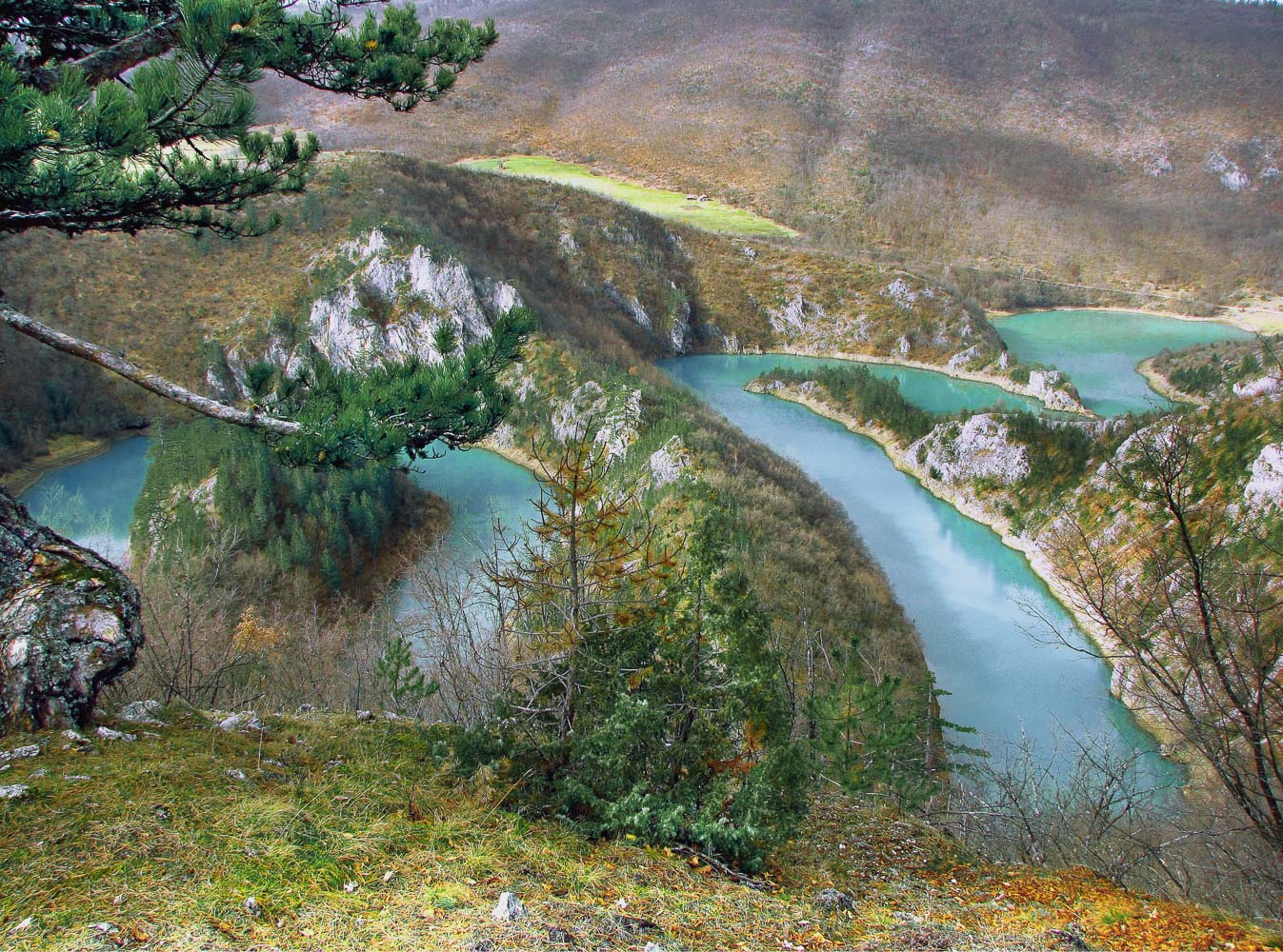
Meanders of Cehotina
The meanders of Ćehotina, which are located 20 kilometers from Pljevlja, on the Pljevlja-Vrulje road, in the village of Mataruge, are a point from which all the power of nature can be seen. The Ćehotina River is 125 kilometers long and flows through Montenegro and Bosnia and Herzegovina, where it flows into the Drina. It is a mountain river that rises near the town of Donji Kolašin, near the border of Serbia and Montenegro.
The "Meanders of Ćehotine" lookout point, from which the view flies through the meanders, has been arranged and arranged. Next to the turn off from the main road, there is an information board, from which you can go by car for another kilometer on a macadam road, and after that another hundred meters on foot. A cooler with a table and benches, as well as a protective fence, has been installed at the viewpoint itself. From the lookout point, you can see a view like a postcard, which is completed by the crooked, as the locals say, hundred-year-old pine tree.
It makes meanders along its course in Pljevlje. Meanders are, by the way, a geographical term for a meandering river bed - bends, meanders (or bends) that a river makes during its flow, named after the Asia Minor river Meander, which usually has a meandering course. There is still a frenzy on Instagram for photos with magical curves on Ćehotina.
Biogradska Gora (one of the 3 European rainforest)
Between the Tara and Lim rivers, in the central part of the Bjelasica mountain, is the Biogradska Gora National Park. In the heart of the rainforest is Lake Biograd, whose small deck for mooring boats has become an absolute hit on social media. Biogradska Gora is a destination for taking pictures of many on social networks, but also of newly married couples. Whenever you go there, you won't go wrong.
In summer, green is the dominant color in the landscape. Around the lake itself, there is a path that is ideal for a leisurely walk - about five kilometers long.
"Here, nature takes care of itself, and people make sure that no one disturbs that harmony. Although the lake is open to visitors, it is strictly controlled so that the human impact on this area is as small as possible, so that Biogradska Gora and its lake will forever preserve their pristine beauty and purity", it is written on the official website of the Municipality of Kolašin.

Travel organization of Kolašin
Another location on Lake Skadar, which was additionally promoted by "Instagrammers", is located in its center. Virpazar is a fairytale place at the crossroads where different roads intertwine. In that area, guests can find what they need most: a fountain with spring water, the shade of old and tall plane trees, organic food and friendly hosts.
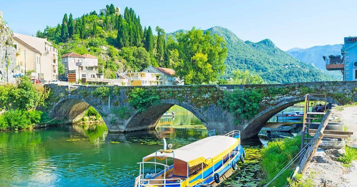
The settlement was created at the confluence of the rivers Orahovštica and Crmnica. By merging, the single-tier source creates the river Virštica, which flows into Lake Skadar. The well-known picnic spot is the main transit station for cruises on the largest lake in the Balkans and for visiting cultural and historical monuments, monasteries and fortifications concentrated on picturesque islands called Gorica. The old bridge was recorded by numerous phone cameras, whether in the background you can see the reeds and bushes of the lake, or the river Virštica that flows under the bridge and flows into the lake.
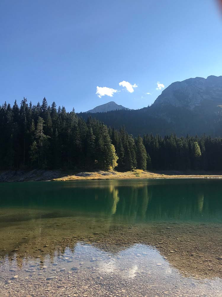
Crno jezero (Black Lake)
Crno jezero is the most famous of the "eyes of Durmitor". It lies at the foot of the peak of Međed and consists of two smaller lakes - Veliki and Mali jezera. The two lakes are connected by a narrow stream and thus form two separate bodies of water.
Black Lake is the main tourist attraction of the Durmitor area. The lake is accessible and can be reached on foot from the center of Žabljak. Three and a half kilometers of hiking trails surround the lake - a popular recreation destination.
The pier on the lake is also popular as a photography destination. An indescribable feeling arises when there is a person in the foreground, and in front of or behind him is a dark water surface surrounded by a green forest.
Bridge on Đurđevića Tara
This list would not be complete without the "tear of Europe" - the Tara River. It is part of the Durmitor National Park and enjoys the highest degree of protection - a UNESCO area. There are many interesting locations for photography, but the most interesting is certainly the bridge on Đurđevića Tara.
Built between 1937 and 1940, it is one of the most visited attractions in Montenegro. Hundreds of buses with thousands of tourists come to visit this marvelous combination of nature and architecture every year.
At 172 meters above the Tara River, at the time it was completed, it was the largest traffic concrete bridge in Europe. It has always been a great inspiration to many artists, and its magnificent beauty was admired even by world-renowned architects and engineers. This is supported by the fact that it is included in the list of the 10 most beautiful bridges on the planet.

photo: Tourism organization of Montenegro
Source: Caffe Montenegro
Cover photo: Robert Janković
Montenegro mountains – meet the tall wildlands of our country - Blog
The tourist organization of Montenegro recommends the top 10 places - Blog
From the sea to the mountains in an hour - Blog

National Geographic: Mount Prokletije is the most exciting destination in the world - Blog

Work and enjoy in Montenegro wild beauty
When you subscribe to the blog, we will send you an e-mail when there are new updates on the site so you wouldn't miss them.
About the author
About us
We are Montenegro guide service. We will try to be excellent hosts and guides in answering everything you are interested in while you are on vacation in Montenegro.
Info & Contact
Dast Web Solutions SIA
Āraišu iela 27-6,
Riga LV-1039
info@dastweb.me
Guides
Local informatios
News and Events
Transport informations
Places and stories
Restaurants and bars
Services
Accommodation
Air Tickets
Rent a car
Rent a Yacht
Excursions
Comments